Medieval & Renaissance
Cartographic Sea Monsters
"The sea monsters on medieval and Renaissance maps are one of the most visually engaging elements, and yet they have never before been carefully studied. The subject is important not only in the history of cartography, art, and zoological illustration, but also in the history of the geography of the marvellous and of Western conceptions of the ocean. Moreover, the sea monsters depicted on maps can supply important insights into the sources, influences, and methods of the cartographers who drew or painted them."
{Book jacket liner notes 2013 ©The British Library}
For various reasons, I turn down almost all offers of review books. Slogging through them seems like actual work; I often fear that I won't like the book or - worse - I'll find it boring; there's that whole sense of feeling somehow beholden or else guilty, no matter what write-up I churn out; I'm almost certainly not qualified to judge the quality of the material anyway, and besides, reviewing new books was never meant to be part of this site's admittedly random, but vaguely confined, scope.
But there are very rare occasions when I'm convinced ahead of time that a review copy is irresisitible: the curious and esoteric subject matter means that the book will have fabulous illustrations backed by an interesting story, and knowing that there's a high calibre publishing team backing the project brings gravitas and confidence.
So it is here. Medieval and Renaissance map scholar, Chet Van Duzer, backed by The British Library as publisher, have teamed up to produce a spectacular new book, 'Sea Monsters on Medieval and Renaissance Maps', a topic, oddly enough, for which there is little by way of real precedent. This book will become the sea monster authority by default. Although this beautiful book is a product of academic quality, it is very readable and accessible and requires no prior knowledge.
Rather than sully the waters with my own pedestrian attempt at distillation of the book, I've taken the liberty of scanning a representative range of book images below, along with - hopefully - sufficient text excerpts to give a fair overview of the book's feel and coverage. The quotes and scans appear here courtesy of the author and The British Library but without specific clearance. The images come from major institutions around the world and accompanying citations should be searched or followed for further information. Many of these works are available online.
I first heard of the book some two years ago when a friend of the author wrote with an enquiry and mentioned the project as an aside. So I've had a long-held curiosity about this book even before Chet Van Duzer finally contacted me several months ago with more formal information. I'm only sorry that I've been unavoidably occupied these last couple of months and it has taken until now before I was able to cobble something together.
All the blue text in this post was written by me. All the black text (except for the final quote) was written by Chet Van Duzer^ and are direct quotes and part-quotes from the book. In the majority of cases, the text excerpts are incomplete and there is often much more in the book itself to the back stories and explanations for the different eras and critters and maps and cartographers and significance that the sampling here only hints at. The images are not in the order they appear in the book.
'Sea Monsters on Medieval and Renaissance Maps'
2013 by Chet Van Duzer -
Amazon | The British Library | The University of Chicago Press
+001.jpg "illustration from 'Sea Monsters' by C Van Duzer 2013 courtesy of publisher: British Library")
{Another version is available online in full, see: Bibliothèque de Genève, Ms. fr. 64}
+014.jpg "illustration from 'Sea Monsters' by C Van Duzer 2013 courtesy of publisher: British Library")
"This symbolic political image is very different from the scientific legends about sea monsters on Waldseemüller's 1507 map, and in fact represents a complete and striking repurposing of sea monsters on maps: instead of indicating the dangers to human navigation on the sea, the monster is part of an image that expresses control over the sea."
+011.jpg "illustration from 'Sea Monsters' by C Van Duzer 2013 courtesy of publisher: British Library")
Bottom [R]: "An icthyocentaur playing a viol on the map of Scandinavia in Ortelius's 'Theatrum orbis terrarum'* (Antwerp, 1571) (British Library, Maps.C.3.c.5., map 45)"
+012.jpg "illustration from 'Sea Monsters' by C Van Duzer 2013 courtesy of publisher: British Library")
"The most important and influential sea monsters on a Renaissance map are those on a nine-sheet map of northwestern Europe by Olaus Magnus (1490-1557) titled 'Carta marina et descriptio septemtrionalium terrarum ac mirabilium' (Nautical Chart and Description of the Northern Lands and Wonders), which was published in Venice in 1539, and survives in just two copies, one at the Bavarian State Library and the other at the Uppsala University Library in Sweden.
The map [..] contains a wonderful number and variety of sea monsters, many of which are helpfully identified with names; the Latin text on the map provides more information about them, and there are also detailed descriptions of the monsters in [..] Olaus's 'History of the Northern Peoples'. [..] The sea monsters on his 1539 map reflect an intriguing mixture of invention and information from books. [..]
There are several images of whales on the map, which are illustrated with large tusks and twin tubes on the tops of their heads through which they spout; this fanciful style of depicting whales would prove very influential. [..]
His map is also noteworthy for the distinctive visual style of its sea monsters, a style thoroughly of the Renaissance, and very different from the medieval images of sea monsters - more dynamic and also more whimsical.
Luigi de Anna has suggested that the sea monsters on the map were intended not only to excite the curiosity of the viewer, but also to dissuade fishermen from other countries from entering Scandinavian waters. If this intriguing suggestion is correct, the sea monsters on the map have an innovative economic function not shared by those on other maps."
-
+009.jpg "illustration from 'Sea Monsters' by C Van Duzer 2013 courtesy of publisher: British Library")
"A ship landing on a whale mistaken for an island in an early thirteeth century bestiary (London, British Library, Harley MS 4751, f. 69r, c. 1230-1240)."
"In the Indian Ocean there are whales which are so large that they seem to be islands. And sometimes because of the soil they have on them plants grow on their backs. Men crossing the sea sometimes land on these whales, which, when they feel the movement of men on them, hurry down into the depths, and so the men are drowned."
{Translation - by Chet Van Duzer (our modern sea monster book author) - of a Latin quote from a lost Medieval chart whose legends are preserved in a 15th century manuscript in Genoa: Biblioteca Universitaria MS B. 1. 36.}
"The myth that whales could be mistaken for islands goes back to the 'Physiologus', an anonymous book about animals, plants and magic stones composed sometimes between the second and fourth centuries, and appears in medieval bestiaries."
+010.jpg "illustration from 'Sea Monsters' by C Van Duzer 2013 courtesy of publisher: British Library")
Bottom [R]: "A menacing sea monster on Gastaldi's map of Africa in the 1563 edition of Ramusio's 'Navigazioni', f. 261 (in British Library, G.6820)"
+005.jpg "illustration from 'Sea Monsters' by C Van Duzer 2013 courtesy of publisher: British Library")
[R]: "An aquatic elephant, probably intended for a walrus, from the twelfth century painted ceiling in the Church of St Martin in Zillis, Switzerland."
"[T]he ceiling, though not a map in the modern sense of the word, is [..] {like} an image of the world as a stage for the playing out of a Christian history. The ocean surrounding the earth in the ceiling at Zillis abounds with sea monsters, including sirens and many hybrid creatures such as wolf-fish, goat-fish, rooster-fish, stag-fish, lion-fish, horse-fish, elephant-fish, and so on, which reflect the medieval theory [..] that every land creature had its equivalent in the sea. Here the sea monsters certainly indicate that the edges of the world are full of exotic wonders and dangers [..] {like some other ~contemporary mappa mundi manuscripts, but} [t]he monsters on the ceiling in Zillis may also allude to the diversity and fullness of God's creation."
+016.jpg "illustration from 'Sea Monsters' by C Van Duzer 2013 courtesy of publisher: British Library")
"The book 'Novus orbis..' (The New World of Regions and Islands Unknown tot he Ancients) [..] 1532, is an important collection of travel literature, including accounts of the voyages of Columbus, Vicente Yáñez Pinzón, Amerigo Vespucci, Marco Polo, Ludovico di Varthema, and others.
The Basel edition includes a world map title 'Typus cosmographicus universalis' made by the cartographer Sebastian Münster (1488-1552) and the artist and engraver Hans Holbein the Younger (1498-1543). The borders of the map have images of cannibals, exotic animals, and spices; within the map itself there is a pair of stylized dolphins in the Southern Ocean off the eastern coast of Asia - the traditional location of sirens on maps.
These creatures exemplify a new Renaissance imagery of sea monsters [..] but the dolphins on Sebastian Münster's map are different. They were inspired by classical images of dolphins, and show no resemblance to medieval images of these animals. They are rendered with shading to indicate their three-dimensionality, and are shown in motion, making waves in the water. [..] The visual dynamism [..] and the use of classical sources are typical of Renaissance art, and these monsters mark a new stage in the development of sea monsters on maps."
+002.jpg "illustration from 'Sea Monsters' by C Van Duzer 2013 courtesy of publisher: British Library")
"A marine chicken on the Gerona Beatus mappamundi
(Museu de la Catedral de Girona, Num. Inv. 7 (11), ff, 54v-55v)."
{nb. image is rotated 90 degrees; ie. it is part of the horizontal map border}
"The mappa mundi in the 'Gerona Beatus' stems from the one now missing from the Tábara codex. Its general characteristics are its rectangular shape, the representation of Adam and Eve instead of the four rivers of Paradise, and likewise the location of Paradise at the top of the maps, the appearance of the two possible courses of the Nile, a figuration of the Jordan, the representation of the Danube with many tributaries, the mention of the names of Cappadocia, Mesopotamia and the Arabia Gulf; a legend referring to the land of the Amazons and the new wording of legend about the fourth transequatorial continent."
+003.jpg "illustration from 'Sea Monsters' by C Van Duzer 2013 courtesy of publisher: British Library")
"The map in the 'San Andrés de Arroyo Beatus' [..] is circular as opposed to the rounded rectangles of the Gerona and Manchester maps. It is artistically more sophisticated than the two other maps, with many images of cities, and the mountains as imaginatively depicted as piles of rocks; and it has a dramatic colour palette different from those of the other Beatus maps: the earth is burgundy, and there are stripes of white in the water. [..]
[W]e are no doubt to understand that they {the sirens} are singing seductive songs to the sailors on the ships as the sirens did to Odysseus in 'The Odyssey' - and as sirens are said to do in medieval bestiaries."
+007.jpg "illustration from 'Sea Monsters' by C Van Duzer 2013 courtesy of publisher: British Library")
Bottom [R]: "A sea monster eating an unfortunate sailor - perhaps Jonah - in the Mediterranean off the northern coast of Africa in Sebastian Münster's 'Cosmographia' of 1540 (British Library, Maps.C.1.c2., No. 15)".
+006.jpg "illustration from 'Sea Monsters' by C Van Duzer 2013 courtesy of publisher: British Library")
"{This} small manuscript [..] contains a miscellany of theological, exegetical, devotional and eschatological texts. [..]
{One section}, [t]he zonal mappamundi, presents a striking vision of the circular disk of the earth (divided into climatic zones) [..] surrounded by an enormous serpentine monster which is devouring its own tail (known as uroborus {or ouroborus}, from the Greek for 'tail-eater'), and beyond the uroborus in the ocean there are four hybrid sea monsters with human heads and piscine bodies and tails - {two have terrestrial origins or features, two have aquatic origins or features}.
Outside the circle of the ocean there are demonic personifications of the four rivers of Paradise, each of whom pours water from an urn that flows into the circumfluent ocean. The four sea monsters in the ocean are mermen or male sirens with very long noses."
+008.jpg "illustration from 'Sea Monsters' by C Van Duzer 2013 courtesy of publisher: British Library")
Bottom [R]: A huge sea monster attacks a galley in the Aegean, while the seamen try to fend it off with spears, on Nikolaos Sophianos's 'Totius Graeciae Descriptio' of 1545 (Basel, Öffentliche Universität Bibliothek, AA 89).
+013.jpg "illustration from 'Sea Monsters' by C Van Duzer 2013 courtesy of publisher: British Library")
"{The Ptolemy manuscript} in Madrid contains a truly remarkable number and variety of sea monsters - in fact the richest collection of of sea monsters in any one manuscript. [..] There are a total of 476 sea creatures on these maps; of these, 411 are generic sea serpents, lampreys, fish, flounders and crabs. If we subtract the generic creatures, this leaves an impressive 65 more or less exotic creatures. [..]
The folios {including the above image} with the highest concentrations of exotic creatures were apparently so decorated simply because they contained large expanses of open water and because the artist felt inspired, rather than because he had read reports of exotic creatures in those areas."{The whole of this 1450s Madrid Ptolemy manuscript is available to view in-browser as a .pdf -- search on *Ptolomeo* at Biblioteca Digital Hispánica}
+015.jpg "illustration from 'Sea Monsters' by C Van Duzer 2013 courtesy of publisher: British Library")
Bottom [R]: "A walrus in the northwest Pacific on Mercator's globe of 1541, which clearly derives from Olaus Magnus's image, but now the cartographer has placed the creature in the water. (Wolfenbüttel, Herzog August Bibliothek, no shelfmark)."
+004.jpg "illustration from 'Sea Monsters' by C Van Duzer 2013 courtesy of publisher: British Library")
"The map supplies no geographical details about the earth, but instead presents it as a stage for the playing out of Christian history, as some other mappemundi do: specifically, it is an illustration of the part of hte Apocalyptic drama described in Revelation 7:1-8. It shows the 'four angels standing on the four corners of the earth, holding the four winds of the earth, that the wind should not blow on the earth, nor on the sea, nor any tree', and an angel comes from the east carrying the seal of God gather in the centre of the map. The earth is labelled terra, and the circumfluent ocean mare; there are several large fish in the ocean and at the left hand side of the map, that is, in the north, there are two sea monsters."
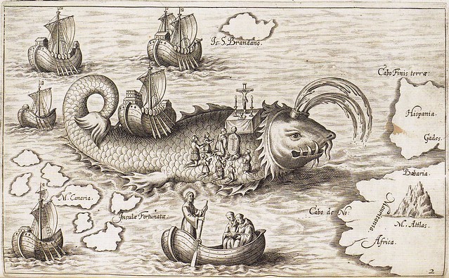
"St Brendan's ship on the back of a whale, and his men praying, in Honorius Philoponus, 'Nova typis transacta navigatio' (Linz: s.n., 1621), p.12 (British Library, G.7237)."
{See previous post on BibliOdyssey for more background & images from this the extraordinary work}
The following quote comes from the Online Gallery at the British Library:
"Religion and entertainment could merge in medieval saints lives. One of the best examples is the story of the voyage of an Irish saint, Brendan, who visits a series of islands with nearly surreal inhabitants and fauna. His journey is a kind of imaginative and even humourous reflection of the life and prayer of a monk. In the 12th century, the bride of King Henry I, Aeliz of Louvain, asked a monk named Benedeit to write a poem of the voyage of St Brendan in Anglo-Norman French. This manuscript has a copy of Benedeit's poem followed by a 'Voyage of Brendan' in Latin prose.
The Latin 'Voyage of St Brendan' is a separate work, not a translation of the French poem. In the middle ages, this manuscript belonged to the priory of Durham cathedral--this is known from an inscription in a part of the manuscript that is now bound in another volume. Monks and canons enjoyed saints' lives as much as anyone else, and they had to read them as part of their daily devotions." {link}
- 'Sea Monsters on Medieval and Renaissance Maps' 2013 by Chet Van Duzer can be purchased from Amazon | British Library | U Chicago Press.
- Books by Chet Van Duzer at Amazon.
- Chet Van Duzer page at Academia.edu.
- A few reviews I came across: Boston.com | Jonathan Crowe | WSJ -<>- there are more around.
- ADDIT: Review at The Smithsonian by Hannah Waters.
- My favourite quote about our Sea Monster book comes from (I think) Lapham's Quarterly 29 August 2013 podcast between Aidan Flax-Clark and the author, Chet Van Duzer wherein Flax-Clark says: "In the large-format, hardcover that this thing is, it’s basically as near to the ultimate nerd-level coffee table book that you could ever want, and I love it for that." I totally agree! Anyone who visits this blog should buy this book. We are the target audience.
- Previously on BibliOdyssey - cartography & monsters.
- The presence of this post shouldn't be taken as a change in heart on accepting review books. 99% of the time I will say no, so please don't waste your energy enquiring unless you know this website and my tastes really well. And even then, the default is "no!".
- This post first appeared on the BibliOdyssey website.


8 comments :
Great post, I will have to get a copy of this book.
You may enjoy this related post, regarding the original source of "Here Be Dragons" from the History Blog: http://www.thehistoryblog.com/archives/26763
Thanks, Kevin
I presume you are aware of of Heck and Cordonnier's (2011) A Grand Medieval Bestiary, which collects numerous illustrations with accompanying text (written by the authors) about 100 illuminated critters.
Thanks ko & Michael. Here are clickable links to the pieces mentioned:
-<>- History Blog post
-<>- Amazon listing for A Grand Medieval Bestiary
I don't believe I've heard of that one Michael. There are quite a few on the topic around of course. It certainly looks pretty good/comprehensive! Shall put it on my 'one day' list.
I enjoyed this very much! Modern maps are so boring aren't they? I've missed seeing you post for awhile. Good to see you again! Hugs! deb
Great post - I definitely need to get my hands on this book so that I can finally capture a marine pig-dog.
Yes, there really should have been associated instructions for trapping the beasties ;- ) I'll suggest that as Chet's next book: 'Monster Fishing for Dummies'.
I will get this book!
On another note, if you do not know this one already, I think you would enjoy it:
http://www.amazon.com/City-Laughter-Satire-Eighteenth-Century-London/dp/0802716024
I come upon this article only a month after listening to a podcast interviewing the author Chet Van Duzer. If you go to iTunes and look up the Monster Talk podcast the name of the episodes are "The Key to the Legend of the Map Monsters and "More Map Monsters."
If you don't have, or can't stand iTunes, you can go directly to the Monster Talk site and listen to the episodes on their website.
Post a Comment
Comments are all moderated so don't waste your time spamming: they will never show up.
If you include ANY links that aren't pertinent to the blog post or discussion they will be deleted and a rash will break out in your underwear.
Also: please play the ball and not the person.
Note: only a member of this blog may post a comment.